Crop production, food distribution and trade are vulnerable to disruptions resulting from climate change. Building resilience into the food supply chain will help make these systems more robust, ensuring an equitable, affordable and year-round access to nutritious food for all, regardless of location. The greatest challenge? Access to information.
Despite challenges in information accessibility, risks can be modelled and decision-making processes can be improved to inform policy. Andy gives a practical example, “Some years ago, we looked at food transport networks in different countries. The development of the model was very important: could we create a valid model and prove its validity? Australia was unexpectedly vulnerable in terms of transport resilience. It’s a huge country, with people living around the edges.”
Andy monitors how things change over time and looks at the movement of people and goods. He uses spatial information from satellites and existing databases to do this. The model that Andy talks about consists of information on the locations where food is grown or produced, the locations where it needs to travel to in order to meet demand by consumers, and the transport networks that connect the two.
Yue’s work is related to this: she uses an agent-based modelling approach to understand the dynamics of the food system. Yue explains, “This approach is complex in that it takes into account not only biophysical processes, but also information about how people manage the land, use fertiliser and irrigation, and use the social network to apply correct knowledge.”
Understanding the human side is essential for the food system in general. An agent-based model can simulate and include decision-making processes. It can also include other food system actors, such as supermarkets and transport. Yue designs different scenarios to experiment with modelling the effects of climate shocks and policies to present options.
The next step in the modelling of risks en route from farm to fork
The issue of global food security is strongly related to the challenge of information accessibility. This challenge is twofold: satellite information cannot give information about transportation of food – the data isn’t granular enough – and relationships between people who manage the flow.
“Tracking food from one place to another isn’t feasible with satellite data only.”, says Andy, and he continues: “To gain insights, you need to know the details of shipments and the concrete movements of goods. Then you can understand the dependencies on particular routes, exposures to risks, and look at alternatives.” Yue concurs, and says, “Data is the biggest challenge, and from a broader perspective, also insights in the relationships between people in the supply chain, including the farmers, the middle men, and the consumers. It’s all about how they collectively shape the flow. This cannot be sensed from space.”
Accountability is the key in tracing the food flow. Farmers can produce the same commodity, but the costs can vary per site. When we can have a real understanding of the economic, environmental and social costs, then we can make better informed decisions and choose better production sites. “The bottleneck is the data, we need a better data system to do this kind of accounting.”, according to Yue and Andy.
Working across disciplinary borders: combining models
While Andy and Yue focus on the global flow of food, Ahmadreza (Reza) Marandi, at TU Eindhoven, researches food security closer to home, for the Netherlands. His work offers a complementary view, because it is a complex and costly process of getting food into the country. There are all kinds of risks to account for, such as political barriers and risks to trade. In this case too, if we have a better understanding where food comes from and what routes they follow, than we can look into options and optimise for a resilient supply chain that is able to deal with shocks and disruptions.
After some initial collaborations, the current idea is to use Reza’s optimisation model on supply and demand to capture soya production. Andy is interested in looking at the risks of climate change in the soya supply chain, while Yue provides the climate change model for future climate scenarios. What makes Reza’s optimisation model stand out is that it includes more than only the economic costs of transportation. Andy says, “His model is definitely an improvement to the standard model, because it also looks at other costs, such as deforestation, and carbon emissions at a national level.”
So, what happened in Australia?
After Andy and his colleagues finished their report for the United Nation’s Food and Agriculture Organization some years ago, there was a flooding on a marked route in the model. This ‘high-impact, low-probability’ event resulted in a 3,000-kilometre detour for perishable foods. Andy says: “This was real-life proof about resilience and impacts of disasters. The model showed that this was an unexpected flag, and then it actually happened.” This underscores Andy and Yue’s message that building resilience into the food supply chain is possible and that science can contribute to policy-making for affordable, year-round access to nutritious food for all.
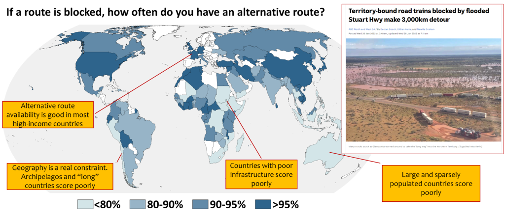
This figure includes graphics from ABC News, link, and the FAO Agricultural Development Economics Technical Study, link.
More information

Credits
Interview and text edited by Nienke D. Nijenhuis. The banner image: United States Geological Survey – USGS on Unsplash.
Variously shaped fields of crops decorate the rich Canterbury Plains on New Zealand's South Island. This 2015 Landsat image shows the farmland abutting the Waimakariri River that winds down toward the city of Christchurch and ultimately the Pacific Ocean.